
Before we can understand the project management aspects of the ascent of Everest, it is essential to understand the topography of Everest and it’s immediate surroundings.
Everest is one of three Himalayan peaks that are clustered close together and give rise to the Khumbu Glacier. While Everest (29,035 ft) is well renowned, the other two are lesser know – Lhotse and Nuptse (though Lhotse is the 4th highest mountain on the earth!). Between them, these three peaks enclose a hidden valley which was named by Mallory as the Western Cwm. This valley forms the head of the Khumbu glacier and slopes downwards (from 22,000 ft at the foot of Lhotse to 20,000 ft) over a distance of about 3 miles. Then it spills abruptly down 2000 ft in what is known as the Khumbu Icefall (which is a solid form of a waterfall).
Here is a picture that is worth a thousand words:

Ignore the camps marked on this route. The first ascent had significantly more camps than shown on this route. Also, North is to the left of the image.
Here is how it looks in Google Maps:

This Google view shows the traditional map orientation of North being the top of the page. The place marker A shows the Everest peak. North of the Everest ridge is Tibet and the Khumbu Glacier itself lies in Nepal.
If you walk up the lower reaches of the Khumbu Glacier towards its source, the sharp bend in the river keeps the Western Cwm completely hidden:
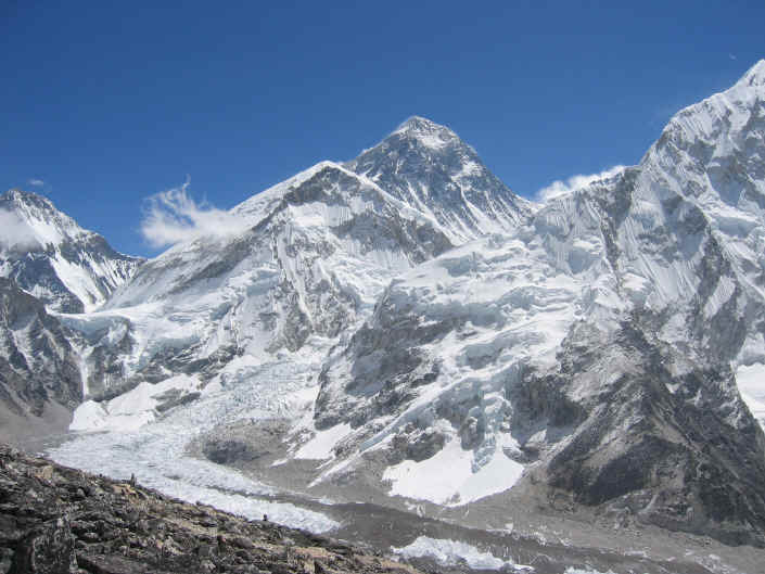
Given this layout, the Khumbu Icefall is the first barrier that a would-be conqueror of the Everest faces.

The Khumbu Icefall. Observe the tiny ants toiling up the Icefall (bottom left)!
Squeezed between the shoulders of Everest and Nuptse, the ice resembles a gigantic cascade, pouring in leaping waves and eddies over submerged boulders towards us. Almost, you might expect to hear the roar of the immense volume of foaming water which, after flowing peacefully to the brink of the cliff above, is now plunging down with terrifying power. But it has been gripped by the intense cold, frozen into immobility, a silent thing, its force restrained. But not quite. For the labyrinth of broken ice is moving, its surface changing, if not at the pace of water, at least at a speed which makes it a perilous problem to surmount.
– The Ascent of Everest, John Hunt, p 104
If he surmounts this barrier, our would-be conqueror enters the Western Cwm. Here is what the Western Cwm looks like on a sunshiny day:
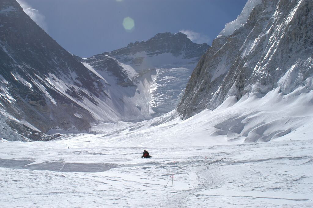
In the Western Cwm
Up ahead, dead straight, at the end of the cul-de-sac, is the impressive Lhotse Face. To the left is the western ridge of the Everest and to the right is the Nuptse ridge.
The would-be conqueror now proceeds all the way to the end of the cul-de-sac and this is what he sees:

The Lhotse Face with the Geneva Spur and the South Sol on the left
To give you an idea of scale, this photographs covers an elevation of slightly less than 6,000 ft (between the foot of the Lhotse – 22,000 ft – and the top of Lhotse (27,939 ft)!
The would-be conqueror now proceeds to climb up the Lhotse Face. But, instead of going all the way to the peak of Lhotse (who wants to conquer the fourth largest mountain when Everest is right next door?), half way up he traverses to the left and proceeds towards the big, jutting rock (which is called the Geneva Spur). He then clambers on the right side of the Geneva Spur to reach the place on the top left where the Everest’s South East ridge starts rising. This place is known as the South Col – a wind-swept, desolate depression between Everest and Lhotse which has seen lots of action over the years (the worst action being in 1996 when nine climbers died near-abouts here):

The South Col
From the South Col, the final assault on the Everest begins – up the South East ridge on to the South Summit which is 300 ft lower than the actual summit. From the South Summit, it is one straight ridge (called the Summit Ridge) all the way to the top of the Everest:

The Summit Ridge. Observe the tiny ants almost at the summit!
You can also see what a “ridge” really is. If you slip to the left, you are back where you started – on the Western Cwm. If you slip to the right, welcome to Tibet!
The expedition we are concerned with set up nine camps before reaching the summit.
- Base Camp downstream from the Khumbu Icefall.
- Camp II half way up the Icefall.
- Camp III at the top of the Icefall.
- Camp IV (Advance Base) half way up the Western Cwm.
- Camp V at the foot of the Lhotse Face.
- Camp VI and VII on the Lhotse Face.
- Camp VIII (Assault Camp) on the South Col.
- Camp IX (which Hillary and Tenzing setup and used for an overnight halt en-route to the summit) on the South East ridge.
Here is a overview of Camp IV and higher:

This then is the topology that the 1953 British Everest Expedition set out to conquer.

Pingback: 3 Mountains We All Have To Climb : Smartstartcoach